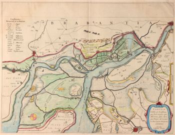
Breda 1649
Joan Blaeu
€ 1.650
Inter-Antiquariaat Mefferdt & De Jonge
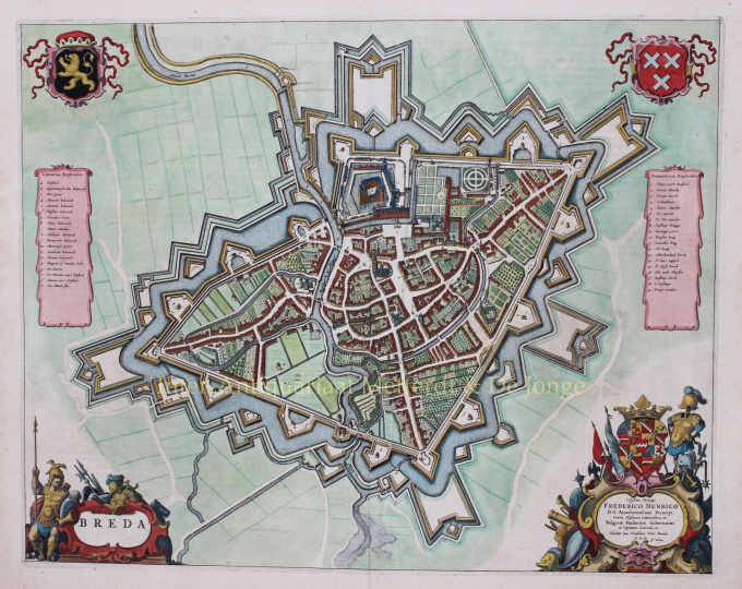
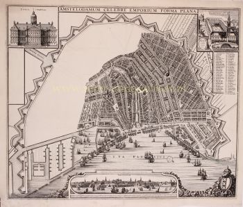
- About the artworkPlattegrond van Breda, kopergravure uitgegeven te Amsterdam in 1649 door Joan Blaeu, als onderdeel van diens Toneel der Steden van de Vereenighde Nederlanden. Later met de hand gekleurd. Afm. 41 x 54 cm. Tijdens de Tachtigjarige Oorlog (1566-1648) was Breda afwisselend in handen van de Spanjaarden en de opstandige Nederlanders. In het begin van de oorlog werd de vesting gemoderniseerd en voorzien van aarden bastions. In 1577 verlieten de Spaanse troepen de stad, waarna hij ingenomen werd door muitende Duitse soldaten. Deze moesten met veel geld betaald worden om te voorkomen dat zij de stad zouden plunderen. Daarna werd de stad voor de prins van Oranje ingenomen door de graaf van Hohenlohe. Nadat Willem van Oranje in dat jaar in Breda was teruggekeerd werden nieuwe aarden bastions opgeworpen. Aan de zuidzijde kwam een sluis in de Mark om het rivierwater dat in de grachten stroomde, op te stuwen. De nieuwe vesting werd door Jocob Kemp in 1593 gekarteerd. Dit is bekendste Bredase plattegrond, met stratenpatroon en bebouwing in opstand getekend. Hoewel de kaart pas in 1649 werd uitgegeven is de weergegeven situatie van rond 1622, met de vestigingsuitbreidingen van Maurits maar zonder kroonwerken, een situatie die onveranderd bleef tot 1682 De kaart is gebaseerd op de opmetingen die door Balthasar Florisz. van Berckenrode waren verricht ten behoeve van zijn belegeringskaart uit 1637. Het octrooi op deze laatste kaart verliep in 1643. Na deze datum kon zijn kaart vrijelijk worden gereproduceerd. De kaart is opgedragen aan Frederik Hendrik. Een herdruk van de kaart van Blaeu verscheen na 1698 bij Frederick de Wit. (Al was de rechterbovenhoek van de koperplaat afgebroken, waar het stadswapen stond gegraveerd.) Prijs: Euro 1.650,-
- About the artist
Joan Blaeu (1596-1673), was born on the 23rd of September in 1596 in Alkmaar.
He was a Dutch cartographer born in Alkmaar. He followed the footsteps of his father, cartographer Willem Blaeu.
In 1620 he became a doctor of law but he joined the work of his father. In 1635 they published the Atlas Novus (full title: Theatrum orbis terrarum, sive, Atlas novus) in two volumes. Joan and his brother Cornelius took over the studio after their father died in 1638. Joan became the official cartographer of the Dutch East India Company.
Blaeu's world map, Nova et Accuratissima Terrarum Orbis Tabula, incorporating the discoveries of Abel Tasman, was published in 1648. This map was revolutionary in that it "depicts the solar system according to the heliocentric theories of Nicolaus Copernicus, which show the earth revolving around the sun.... Although Copernicus's groundbreaking book On the Revolutions of the Spheres had been first printed in 1543, just over a century earlier, Blaeu was the first mapmaker to incorporate this revolutionary heliocentric theory into a map of the world."
Blaeu's map was copied for the map of the world set into the pavement of the Groote Burger-Zaal of the new Amsterdam Town Hall, designed by the Dutch architect Jacob van Campen (now the Amsterdam Royal Palace), in 1655.
Blaeu's Hollandia Nova was also depicted in his Archipelagus Orientalis sive Asiaticus published in 1659 in the Kurfürsten Atlas (Atlas of the Great Elector). and used by Melchisédech Thévenot to produce his map, Hollandia Nova—Terre Australe (1664).
As "Jean Blaeu", he also published the 12 volume "Le Grand Atlas, ou Cosmographie blaviane, en laquelle est exactement descritte la terre, la mer, et le ciel". One edition is dated 1663. That was folio (540 x 340 mm), and contained 593 engraved maps and plates. In March 2015, a copy was on sale for £750,000.
Around 1649 Joan Blaeu published a collection of Dutch city maps named Toonneel der Steeden (Views of Cities). In 1651 he was voted into the Amsterdam council. In 1654 Joan published the first atlas of Scotland, devised by Timothy Pont. In 1662 he reissued the Atlas Novus, also known as Atlas Maior, in 11 volumes, and one for oceans.
A cosmology was planned as their next project, but a fire destroyed the studio completely in 1672.
Joan Blaeu died in Amsterdam the following year, 1673. He was buried in the Westerkerk at Amsterdam.
Are you interested in buying this artwork?
Artwork details
Related artworks
- 1 - 4 / 12
Unknown artist
A large wall map of Asia by Nicolas de Fer 1647 - 1720
Price on requestZebregs & Röell - Fine Art - Antiques
1 - 4 / 24- 1 - 4 / 12

