Specerijeneilanden, Molukken, Indonesië 1660
Johannes Janssonius
Momenteel niet beschikbaar via Gallerease
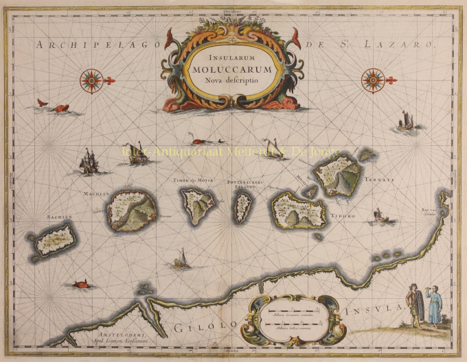
- Over kunstwerkDETAILED MAP OF THE DUTCH-CONTROLLED SPICE ISLANDS “Insularum Moluccarum Nova Descriptio”, copper engraving published in Amsterdam by Jan Jansson [Johannes Janssonius] c. 1660, with original hand colouring. Size: 38 x 49,5. Fine map of the Spice Islands based on the description by Jan Huyghen van Linschoten. This map depicts the islands that provided, first the Portuguese and then the Dutch, with a monopoly on the lucrative spice trade. Each of the islands (Bacan, Makian, Moti, Mare -in Dutch times called "Pottebackers Eyland" [potters’ island], Tidore, Ternate and Hiri) is shown with groves of the prized clove and nutmeg trees and the location of their protective fortresses. Along the bottom of the map we see the coastline of Halmahera (in Dutch times known as Gilolo Island). The lower right corner features a Moluccan couple in Europeanized native dress. Indicative of the area’s commercial importance, Jansson has filled the seas with both European and local ships and sea monsters roam the Molucca Sea. Price: Euro 395,- (incl. frame)
- Over kunstenaar
Janssonius werd geboren in Arnhem als zoon van Jan Jansz, een drukker en uitgever aldaar. Op jonge leeftijd verhuisde hij naar Amsterdam, het toenmalige centrum van de boekdrukkunst- en kaartenhandel. In 1612 trouwde hij met Elisabeth Hondius, dochter van Jodocus Hondius. Elisabeth overleed in 1627 en Janssonius hertrouwde in 1629 met Elisabeth Carlier. Hij ging werken voor zijn schoonvader en zette na diens dood samen met Henricus Hondius (zoon van) de uitgeverij voort. Deze werd uitgebouwd tot een der grootste van die tijd. Er waren vestigingen in onder andere Berlijn, Frankfort, Genève, Lyon en Stockholm.
Onder Janssonius' leiding werd de Mercator-Hondius Atlas uitgebreid en gepubliceerd als Atlas Novus. Deze, aanvankelijk uit één deel bestaande uitgave werd spoedig een uit meerdere delen bestaande atlas, op verzoek aangevuld met zeekaarten en/of hemelkaarten. Er waren uitgaven in het Nederlands, Frans, Spaans en Latijn. Net als zijn tijdgenoten maakte ook Janssonius gebruik van bestaande koperplaten, onder andere uit de stedenboeken van Braun & Hogenberg en de Description de touts les Pays Bas (Beschrijvinghe van alle de Neder-Landen) door Lodovico Guicciardini - (Cornelis Claesz. editie) uit 1609. Alhoewel Janssonius vaak is beschuldigd van het kopiëren van werk van Willem Blaeu mag opgemerkt worden dat er ook kaarten van Janssonius eerder op de markt verschenen.
Na Janssonius' dood werd de firma voortgezet door zijn schoonzoon, Johannes (Jan) van Waesbergen, die gehuwd was met zijn dochter Elisabeth Janssonius (1615-1681). Veel koperplaten van de stedenboeken werden (soms lichtelijk aangepast) gebruikt door Frederik de Wit. Het pand op de Dam werd verhuurd aan Gerard Valck; ook een aantal drukplaten zijn in 1694 door hem opgekocht.
Artwork details
Related artworks
- 1 - 4 / 5
- 1 - 4 / 24

