Caribbean, Windward Islands  by Joachim Ottens
Scroll to zoom, click for slideshow

Caraibi, Isole Sopravento 1719 - 1723

Joachim Ottens

€ 975

Inter-Antiquariaat Mefferdt & De Jonge

  • A proposito di opere d'arte
    DETAILED MAP OF THE WINDWARD ISLANDS “Tabula novissima atque accuratissima Caraibicarum insularum sive Cannibalum : quae etiam Antillae Gallicae dicuntur, item insulae Supraventum, et in Archipelago Mexicano sitae sunt, ac detectae a Christ. Columbo Ao. MCCCCLXXXXIII” [Latest and most accurate map of the Caribbean or Cannibal Islands: also called the French Antilles, or Windward Islands, located in the Archipelago of Mexico, which were discovered by Christopher Columbus in the year 1493.] Copper engraving “after the observations of skilful sailors” made by Reinier Ottens and printed by the Window of Joachim Ottens  in Amsterdam 1719-1723. With original hand colouring. Size: 58 x 48 cm. Detailed map of the Windward Islands from Guadeloupe south to Grenada, including the small islands of Mustique (Grenadines) and Ronde Island (Grenada), with a large inset map of Martinique. Grenada has been moved north and is shown west of Carriacou island, in order that it fits on the sheet. Apart from topographical information, there are some notes of historic interest. According to the map tens of thousands live on Martinique (“Matanino as the locals call it and occupied by the French since July 1635”) and its tobacco is of the best quality. La Désiderade island was discovered by Christopher Columbus in 1493 on his second journey to America. “The island of Guadeloupe, called Carukeira [The Island of Beautiful Waters] by the locals, is very fertile with rice, maize, potatoes, ginger and sugar of different qualities. It is crowded with all types of parrots.” The island of Barbados has been occupied by the English in 1627. “St. Vincent, where the Caribs live, is most populated.” Price: Euro 975,-  
  • A proposito di opere artista

    Joachim Ottens (1663 - 1719) ei suoi figli Renier (1698 - 1750) e Joshua (? - 1765) erano eccezionali librai olandesi ed editori di mappe.

    Il periodo dal 1630 al 1700 fu il "periodo d'oro" della cartografia olandese. Le mappe erano percepite come opere d'arte, il lavoro manuale era molto apprezzato, l'incisione era ai massimi livelli, ma dal punto di vista dell'accuratezza geografica, le mappe dei maestri olandesi erano inferiori alle mappe prodotte in Germania, Francia e altri paesi europei .

    Joachim, il fondatore della ditta Ottens, è nato ad Amsterdam e inizialmente ha lavorato come incisore su rame. Nel 1711 fondò la propria ditta che si occupava di editoria e tipografia, vendendo libri, mappe, cartoline e illustrandoli.

    Sebbene Joachim morì pochi anni dopo, i suoi figli, Renier e Joshua, continuarono con successo l'attività del padre. Il contributo più significativo alla cartografia della famiglia Ottens furono gli enormi atlanti multivolume che realizzarono su ordinazione, come Atlas Major. Alcuni numeri di Atlas sono composti da più di 800 mappe emesse separatamente.
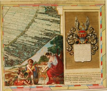
Sei interessato ad acquistare questa opera d'arte?

Artwork details