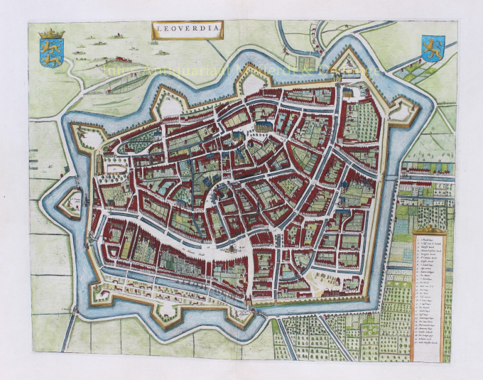
Leeuwarden 1649
Joan Blaeu
€ 650
Inter-Antiquariaat Mefferdt & De Jonge
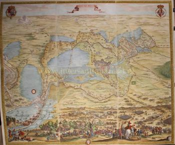
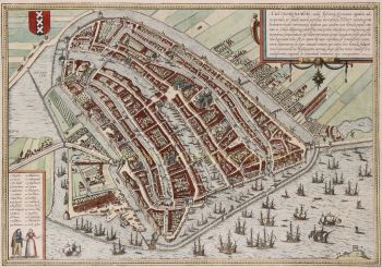
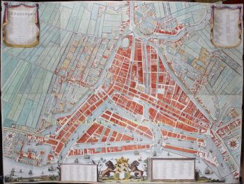
- About the artworkLEEUWARDEN IN HAAR GOUDEN EEUW “Leoverdia” kopergravure van de stad Leeuwarden uitgegeven door Joan Blaeu als deel van diens Stedenboek, uitgegeven 1649-1654. Later met de hand gekeurd. Afm. 40 x 50 cm. De stad is met omliggende landerijen, pleziertuinen en warmoezerijen aan de zuidoostzijde weergegeven. De gebouwen zijn in opstand getekend en hoofdletters en cijfers verwijzen naar de legenda rechtsonder. Linksboven staat het wapen van Friesland, rechtsboven het wapen van Leeuwarden. De zestiende en zeventiende eeuw vormden een gouden tijd voor Leeuwarden. De stad kreeg aanzien doordat het de verblijfplaats werd van de Friese Nassaus die stadhouder werden van de noordelijke provincies. Door de gunstige ligging in een netwerk van beurtveren was Leeuwarden in de 17e eeuw het handelscentrum van Friesland geworden met goede verbinding met andere steden in de Republiek. De stad kwam tot grote bloei. De vele markten en het rijke culturele leven van schilders boekdrukker en schrijvers trokken veel migranten naar de stad en het inwonertal groeide sterk, van 5.000 rond het jaar 1500 tot 16.000 in 1650. Leeuwarden behoorde toen tot de tien aanzienlijkste steden van Nederland. Rond 1670 kwam er een einde aan de periode van groei en bloei en in de daarop volgende 150 jaar werd de stad nauwelijks uitgebreid. Prijs: Euro 650,-
- About the artist
Joan Blaeu (1596-1673), was born on the 23rd of September in 1596 in Alkmaar.
He was a Dutch cartographer born in Alkmaar. He followed the footsteps of his father, cartographer Willem Blaeu.
In 1620 he became a doctor of law but he joined the work of his father. In 1635 they published the Atlas Novus (full title: Theatrum orbis terrarum, sive, Atlas novus) in two volumes. Joan and his brother Cornelius took over the studio after their father died in 1638. Joan became the official cartographer of the Dutch East India Company.
Blaeu's world map, Nova et Accuratissima Terrarum Orbis Tabula, incorporating the discoveries of Abel Tasman, was published in 1648. This map was revolutionary in that it "depicts the solar system according to the heliocentric theories of Nicolaus Copernicus, which show the earth revolving around the sun.... Although Copernicus's groundbreaking book On the Revolutions of the Spheres had been first printed in 1543, just over a century earlier, Blaeu was the first mapmaker to incorporate this revolutionary heliocentric theory into a map of the world."
Blaeu's map was copied for the map of the world set into the pavement of the Groote Burger-Zaal of the new Amsterdam Town Hall, designed by the Dutch architect Jacob van Campen (now the Amsterdam Royal Palace), in 1655.
Blaeu's Hollandia Nova was also depicted in his Archipelagus Orientalis sive Asiaticus published in 1659 in the Kurfürsten Atlas (Atlas of the Great Elector). and used by Melchisédech Thévenot to produce his map, Hollandia Nova—Terre Australe (1664).
As "Jean Blaeu", he also published the 12 volume "Le Grand Atlas, ou Cosmographie blaviane, en laquelle est exactement descritte la terre, la mer, et le ciel". One edition is dated 1663. That was folio (540 x 340 mm), and contained 593 engraved maps and plates. In March 2015, a copy was on sale for £750,000.
Around 1649 Joan Blaeu published a collection of Dutch city maps named Toonneel der Steeden (Views of Cities). In 1651 he was voted into the Amsterdam council. In 1654 Joan published the first atlas of Scotland, devised by Timothy Pont. In 1662 he reissued the Atlas Novus, also known as Atlas Maior, in 11 volumes, and one for oceans.
A cosmology was planned as their next project, but a fire destroyed the studio completely in 1672.
Joan Blaeu died in Amsterdam the following year, 1673. He was buried in the Westerkerk at Amsterdam.
Are you interested in buying this artwork?
Artwork details
Related artworks
- 1 - 4 / 12
- 1 - 4 / 24
- 1 - 4 / 12

