Asia 1638 - 1642
Jodocus Hondius
PapelImprimir
45 ⨯ 56 cm
€ 3.450
Inter-Antiquariaat Mefferdt & De Jonge
- Sobre arteFINE RARE CARTE À FIGURES MAP OF ASIA "Asia recens summa cura delineata Auct. Iud: Hondio". Copper engraving by Jodocus Hondius, published in Amsterdam between 1638-1642 (4th state) by Jan Jansson. With original hand colouring. Verso: German text. Size: 45,5 x 56,5 cm. This highly attractive map embraces all of Asia. The Middle East is very well formed, although the Caspian Sea has the egg-like form it maintained on maps until the 1730s. The Arabian Peninsula is well defined, based on Portuguese sources, and India takes its form after the maps of the Dutch adventurer, Jan Huygen van Linschoten (1596), which, in turn, borrowed from Portuguese sources. Southeast Asia and the Indonesian Archipelago are derived from charts made for the Dutch East India Company (VOC), while China is derived from Jesuit sources, although Korea is an oddly elongated peninsula. The geography of the region would remain an enigma to Europeans until the early 18th Century. Japan's Honshu and Kyushu are recognizable, although the area further to the northeast remains a vast mystery. True to the carte à figures' style, which was the hallmark of the great contemporary period of Dutch Baroque cartography, the map is surrounded on four sides by registers of fine vignettes. Along the top of the map are views of Famagusta (Cyprus), Rhodes (Greece), Damascus, Jerusalem, Aden and Hormuz (Persia). Along the left side of the map are depictions of people in local costume including Syrians, Arabs, Armenians & Persians, Indians, and Sumatrans. On the right side are depictions that include Javanese, Moluccans & Bandans, Chinese, Russians and Tartars. Along the bottom of the map there are further town views of Dutch trading posts Goa (India), Calcutta (Bengal/India), Kandy (Ceylon), Bantam, Gammalamme (Moluccas) and Macao. In addition the map is embellished by a fine title cartouche and ships and sea monsters in the seas. The map was originally conceived by Jodocus Hondius the Younger (1594-1629), whose eponymous father played a large part in the rise of Amsterdam as the dominant cartographic production centre in the 17th Century. The present edition of the map is by Jan Jansson (1588-1664), who married Jodocus the Younger's sister Elizabeth. He transformed the Hondius firm into a powerhouse of geographical publications. Jansson most notably published the Atlas Novus (1638), and the Atlas Major (1660), the 11 volumes of which included a town atlas, a hydrographic atlas, an atlas of the ancient world, and Andreas Cellarius' incomparable celestial atlas. Jansson's works were rivalled only by those of his arch-nemesis Joan Blaeu. The present map is one of the finest depictions of Asia from the apogee of Dutch cartography. Price: Euro 3.450,-
- Sobre artista
Jodocus Hondius (17 de outubro de 1563 – 12 de fevereiro de 1612), também conhecido pela forma latinizada do seu nome holandês, Joost de Hondt, foi um gravador e cartógrafo flamengo, figura central da Idade de Ouro da cartografia holandesa. Para o distinguir do seu filho, é frequentemente chamado Jodocus Hondius, o Velho.
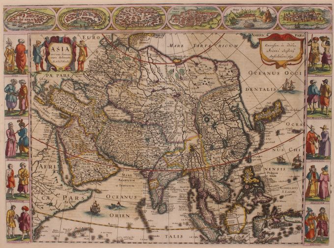
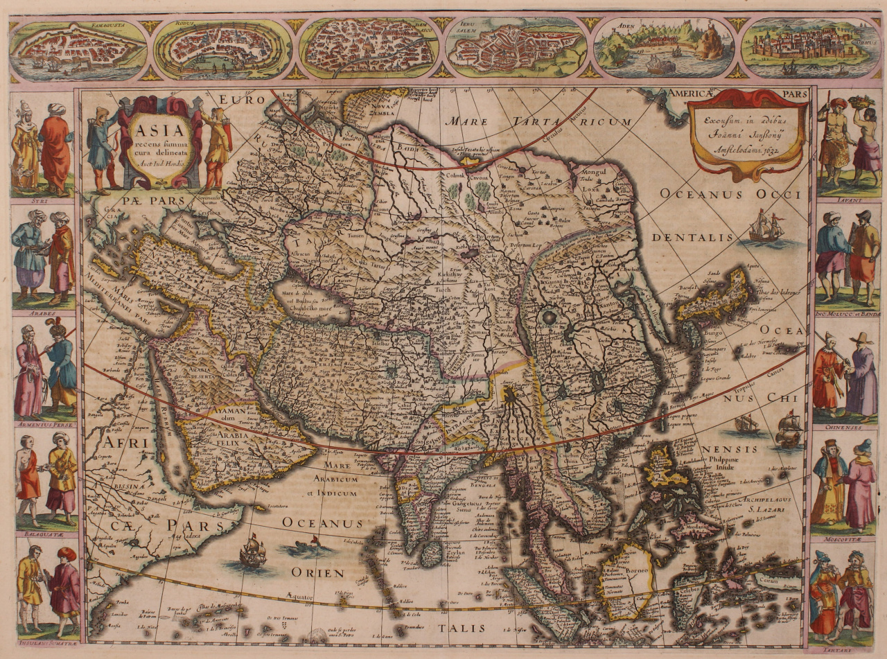
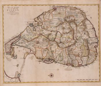
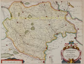
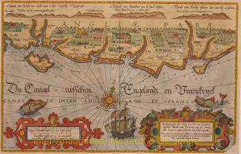
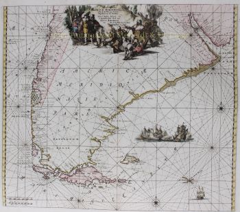
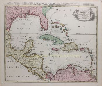
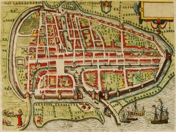
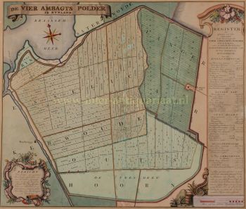
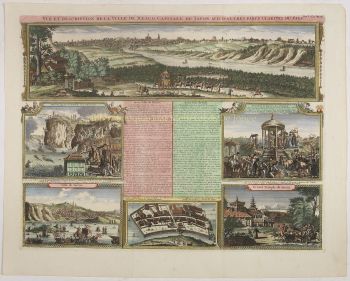
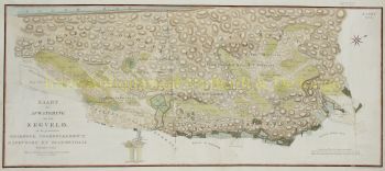
Hondius ganhou destaque pela sua excecional capacidade de combinar a habilidade técnica na gravura com o conhecimento geográfico. É mais conhecido pelos seus mapas pioneiros e influentes da Europa e do Novo Mundo, que ajudaram a moldar a compreensão visual dos territórios recém-explorados na viragem do século XVII. Os seus mapas caracterizam-se pela clareza, precisão e riqueza de detalhes decorativos — qualidades que os tornaram tanto documentos científicos de referência como obras de arte altamente desejáveis.
Um momento crucial na carreira de Hondius foi a aquisição das matrizes de impressão originais de Gerardus Mercator. Numa altura em que a reputação de Mercator começava a decair, Hondius republicou e ampliou estas pranchas, integrando as suas próprias revisões e o conhecimento geográfico recentemente disponível. Este acto não só revitalizou o legado de Mercator, como também assegurou a sua influência duradoura, conduzindo aos célebres atlas de Mercator-Hondius que dominariam a cartografia europeia durante décadas.
Para além da cartografia, Hondius era também um hábil gravador de retratos. Os seus retratos de Francis Drake estão entre as representações visuais mais reconhecidas do famoso navegador inglês, demonstrando ainda mais a versatilidade e o alcance cultural de Hondius.
Como uma das figuras centrais da Idade de Ouro da cartografia holandesa (c. 1570-1670), Hondius desempenhou um papel crucial na consolidação de Amesterdão como o principal centro de cartografia na Europa do século XVII. O seu trabalho uniu arte, ciência e comércio, moldando a forma como o mundo era mapeado, compreendido e imaginado. Hoje, Jodocus Hondius, o Velho, é recordado como um mestre gravador, um editor inovador e um arquiteto fundamental da história da cartografia moderna.
Você está interessado em comprar esta obra de arte?
Artwork details
Related artworks
- 1 - 4 / 6
- 1 - 4 / 24
Gobert Denis Chambon/ Jean Janvier, S.G. Longschamps
Magnificient antiek World map1754
€ 17.500Inter-Antiquariaat Mefferdt & De Jonge
Com curadoria deDanny Bree
1 - 4 / 24- 1 - 4 / 24
- 1 - 4 / 12


![European hunting party] by Artista Desconhecido](https://media-2.gallerease.com/images/cb8cbebf-7709-4817-9bdb-fef8ae1e93cf/350x350/european-hunting-party.jpg)


