Sumatra 1657
Johannes Janssonius
€ 850
Inter-Antiquariaat Mefferdt & De Jonge
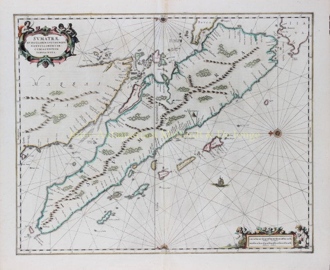
- Over kunstwerkFINE CHART OF SUMATRA AND THE SOUTHERN COASTS OF MALAYSIA. “Sumatrae et Insularum Locorumque Nonnullorum Circumiacentium Tabula Nova.” Copper engraving published by Johannes Janssonius (Jan Jansson) of Amsterdam in 1657 as part of his Atlas Novus. With original hand colouring. Size: 49 x 58 cm. North is orientated to the left of the page. Singapore is probably identified just to the south of Ihor (Johor Bahru) as Senasur. As the map appeared in an atlas of sea charts, little interior detail is given but the coastlines, settlements and principal coastal features are identified. It is one of the earliest detailed depictions of Sumatra and remained the most important map of the region until well into the eighteenth century. A sailing ship and two cartouches embellish the chart: a title cartouche with three allegorical figures and a mileage scale with two surveying putti. In earlier times, Sumatra had been mistaken for the Island of Sri Lanka or Taprobana. The name Taprobana, had been applied to maps of Sumatra from the fifteenth century, after a misunderstanding by the Italian traveller Nicolo de Conti. De Conti dismissed the idea that Sri Lanka was Taprobana and so identified Sumatra as the mythical island described by geographers as Eratosthenes, Strabo, Pliny, Claudius Ptolemy and Cosmas. Price: €850,-
- Over kunstenaar
Janssonius werd geboren in Arnhem als zoon van Jan Jansz, een drukker en uitgever aldaar. Op jonge leeftijd verhuisde hij naar Amsterdam, het toenmalige centrum van de boekdrukkunst- en kaartenhandel. In 1612 trouwde hij met Elisabeth Hondius, dochter van Jodocus Hondius. Elisabeth overleed in 1627 en Janssonius hertrouwde in 1629 met Elisabeth Carlier. Hij ging werken voor zijn schoonvader en zette na diens dood samen met Henricus Hondius (zoon van) de uitgeverij voort. Deze werd uitgebouwd tot een der grootste van die tijd. Er waren vestigingen in onder andere Berlijn, Frankfort, Genève, Lyon en Stockholm.
Onder Janssonius' leiding werd de Mercator-Hondius Atlas uitgebreid en gepubliceerd als Atlas Novus. Deze, aanvankelijk uit één deel bestaande uitgave werd spoedig een uit meerdere delen bestaande atlas, op verzoek aangevuld met zeekaarten en/of hemelkaarten. Er waren uitgaven in het Nederlands, Frans, Spaans en Latijn. Net als zijn tijdgenoten maakte ook Janssonius gebruik van bestaande koperplaten, onder andere uit de stedenboeken van Braun & Hogenberg en de Description de touts les Pays Bas (Beschrijvinghe van alle de Neder-Landen) door Lodovico Guicciardini - (Cornelis Claesz. editie) uit 1609. Alhoewel Janssonius vaak is beschuldigd van het kopiëren van werk van Willem Blaeu mag opgemerkt worden dat er ook kaarten van Janssonius eerder op de markt verschenen.
Na Janssonius' dood werd de firma voortgezet door zijn schoonzoon, Johannes (Jan) van Waesbergen, die gehuwd was met zijn dochter Elisabeth Janssonius (1615-1681). Veel koperplaten van de stedenboeken werden (soms lichtelijk aangepast) gebruikt door Frederik de Wit. Het pand op de Dam werd verhuurd aan Gerard Valck; ook een aantal drukplaten zijn in 1694 door hem opgekocht.
Bent u geïnteresseerd om dit kunstwerk te kopen?
Artwork details
Related artworks
- 1 - 4 / 4
Onbekende Kunstenaar
A large wall map of Asia by Nicolas de Fer 1647 - 1720
Prijs op aanvraagZebregs & Röell - Fine Art - Antiques
1 - 4 / 24- 1 - 4 / 12

