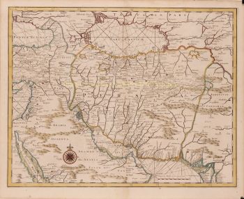
FIRST PRINTED MAP OF THE PACIFIC “Maris Pacifici, (quod vulgó Mar del Zur) cum regionibus circumiacentibus, insulisque in eodem passim sparsis, novissima descriptio.” [A very new description of the peaceful sea, commonly called South Sea with the regions lying around it, and its islands, scattered everywhere]. Copper engraving by Abraham Ortelius as part of his “Theatrum Orbis Terrarum” first published in 1590, here from a Latin edition of 1601. Coloured by a later (?) hand. Size: 34,4 x 49,8 cm. The "Maris Pacifici" map, a masterpiece of early cartography, is considered to be one of the most important maps that appeared in the Ortelius atlases. This was the first printed map to be devoted to the Pacific Ocean, the discovery of which is remembered by the depiction, of Ferdinand Magellan's flagship the 'Victoria'. It was engraved at a time of increasing activity in the Pacific with the English having recently begun raiding the Spanish galleons carrying the gold of Peru up the coast to the Isthmus, as well as those making the arduous journey across from the Philippines to Mexico. Dominating the center of the map is the sprawling Pacific, dotted with prominent islands such as New Guinea, Japan, the Philippines and the Solomon Islands. The coastlines of Asia and the Americas frame this oceanic expanse, indicating the routes crucial to the Manila Galleon Trade that linked Asia and the Americas and global trade throughout the centuries. To the east, the map captures the western shores of the Americas, with newly documented place names provided by explorers such as Francis Drake and Richard Hakluyt. This map played a vital role in spreading the discoveries of these explorers, even as many findings remained politically sensitive and unpublished. Further south, the map includes the “Terra Australis sive Magellanica, nondum detecta” [the Southland or Magellanica, not yet uncovered], reflecting the era's curiosity about uncharted lands. This speculative continent intrigued geographers and explorers, fuelling further voyages of discovery. Abraham Ortelius (1527-1598) was born in Antwerp and after studying Greek, Latin and mathematics set up business there with his sister, as a book dealer and ‘painter of maps'. Traveling widely, especially to the great book fairs, his business prospered and he established contacts with the literati in many lands. On one such visit to England, possibly seeking temporary refuge from religious persecution, he met William Camden whom he is said to have encouraged in the production of the Britannia. A turning point in his career was reached in 1564 with the publication of a World Map in eight sheets of which only one copy is known: other individual maps followed and then – at the suggestion of a friend - he gathered together a collection of maps from contacts among European cartographers and had them engraved in uniform size and issued in 1570 as the Theatrum Orbis Terrarum (Atlas of the Whole World). Although Antonio Lafreri and others in Italy had published collections of ‘modern’ maps in book form in earlier years, the Theatrum was the first uniformly sized, systematic collection of maps and hence can be called the first atlas, although that term itself was not used until twenty years later by Mercator. The Theatrum, with most of its maps elegantly engraved by Frans Hogenberg, was an instant success and appeared in numerous editions in different languages including addenda issued from time to time incorporating the latest contemporary knowledge and discoveries. The final edition appeared in 1612. Unlike many of his contemporaries Ortelius noted his sources of information and in the first edition acknowledgement was made to eighty-seven different cartographers. The "Maris Pacifici" map stands as a testament to the cartographical advancements of the time, combining artistic elegance with geographical science. It remains a significant historical document, offering insights into the geopolitical landscape of the early modern period. Ortelius dedicated his map of the Pacific to Nicolaas Rockox, patrician and senator of Antwerp. Price: Euro 6.500,-