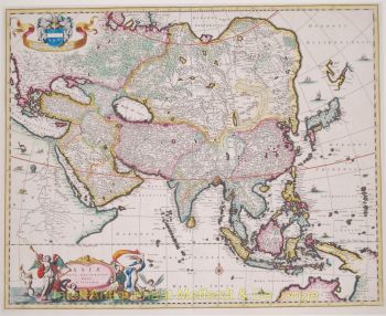
BEAUTIFUL CARTE-À-FIGURES OF CHINA “The Kingdome of China”. Copper engraving made by John Speed in 1626, here in an edition published by George Humble in 1627 as part of the “Prospect of the Most Famous Parts of the World”. Coloured by a later hand. Size: 39,5 x 51 cm. This superb map of central Asia east of the river Ganges is an excellent summary of the European political, cultural, and geographic conceptions of the region during much of the 16th and 17th centuries. China is shown as a vast kingdom surrounded by mountains and the Great Wall, “built by ye King of China against ye breaking in of ye Tartars.” Enormous lakes are connected via a series of rivers, many of which connect to the coast. Another mythical body of water, Lake Chiamay, can be traced back to a map by Giovanni Battista Ramusio in 1554. To the west, Korea is depicted as an island while Japan has a sideways orientation based on the cartography of Abraham Ortelius. The lands of North America can be seen separated by the Strait of Anian in the upper right, with the waterway presumably proceeding on to the fabled Northwest Passage. Legends continue on the annotations throughout the interior, which reference to seductive desert illusions, natural sources of fireproof material, and a flood story in which only one boy survived by clinging to a tree. Surrounding the map are numerous illustrations and views typical of the cartes-à-figures design pioneered by Dutch cartographers in the late 16th century. The top of the page presents four interesting panels; two city views of Macao and Quinzay (Hangzhou) and two scenes showing ‘the manner of their traveling by land’ and ‘the manner of their execution.’ (The crucifixion displayed in the latter would have certainly disgusted contemporary Christians). Vignettes on either side showcase the men and women of various ethnic groups, including soldiers from Japan carrying early matchlock firearms. Two decorative cartouches, a sea monsters and sailing ships, including a junk, complete the appealing aesthetic. On the verso side of the map there is “The Description of the Kingdome of China” where this “now vast Empire" is perceived by Europeans: “The air here is temperate, and the ground fruitful: the mountains and wild fields breed incredible numbers of Cattle, and the Woods wild Boars, Foxes, Hares, Conies, and other useful beasts, which gives us flesh for our food, and skins for our clothing. The tilled ground returns again plenty of Corn, Wheat, and Barley; their higher Poulse trees, and their lower Rice, in great abundance: their gardens pleasant, set with all sorts of flowers, which may delight either the eye, or scent.” “The Chinese are described with a broad face of a dusky colour, crooked nose, small and black eyes, and very thin beard, but long hair on the head: if any be deformed (for so they take it) with a better feature, they are as like to break a jeast upon his handsome comely visage, as a scoffer would upon their ill fashioned countenance. The better sort are clothed in long silk garments; the ordinary people in linen, for they have not yet the art well to weave wool. Their women deck their heads, with gold and precious jewels, seldom show themselves abroad without great attendance of servants. The men in their several employments, are infinitely laborious and ingenious; it is very rare, to see any of them in a strange Country: nor will they easily admit a stranger fare into theirs, unless he be first well tried, for his honesty and good meaning toward their state: they are addicted much to manual arts, for they have excellent practice wits; and indeed for that go beyond any other Nations.” John Speed (1551-1629) was the best-known English mapmaker of the Stuart period. Speed came to mapmaking late in life, producing his first maps in the 1590s and entering the trade in earnest when he was almost 60 years old. John Speed's fame, which continues to this day, lies with two atlases, “The Theatre of the Empire of Great Britaine” (first published 1612), and the “Prospect of the Most Famous Parts of the World” (1627). While The Theatre started as solely a county atlas, it grew into an impressive world atlas with the inclusion of the Prospect in 1627 in fact becoming the first world atlas published an Englishman. Price: Euro 4.500,-